When you think of Scranton, Pennsylvania, you might picture a coal mining town or the setting of “The Office.” However, the city has far more to offer than these claims to fame. It boasts spectacular views from its many parks and riverways. The next time you’re near Scranton, grab your hiking shoes and check out the views at these four scenic spots.
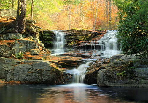
Choke Creek Falls
“Choke Creek Falls (1)” licensed under CC BY 2.0 via Flickr by Nicholas_T
Choke Creek Falls is in the southern corner of Lackawanna County. This stunning waterfall lies in Pinchot State Forest along Choke Creek, which serves as the dividing line between Lackawanna and Luzerne counties.
When you arrive at the forest, locate Phelps Road and take the gated road downhill about 1/3 mile into a clearing. When the trails split, take the path to the right. This trail descends to Choke Creek and a bridge. Cross the bridge, and take an immediate left to follow an unmarked trail that runs along the stream. After you walk for several minutes, you’ll reach the 20-foot waterfall.
You can also stay on the original trail once you cross the bridge. It will take you to the same stream, but you will end up above the falls. Turn left at the stream to find the falls, which you should be able to hear. Once you stop at the falls, you can take a dip in the waters below. The area has a plunge pool frequented by local kids and a rope swing if you’re feeling adventurous.
Lackawanna River Heritage Trail
The Lackawanna River Heritage Trail spans an impressive 70 miles, but you don’t need to tackle the entire trail to witness beautiful scenery. Start in Scranton and work your way north as far as you want. The Scranton trail comprises several sections, including downtown, the Riverwalk, and the Levee Trail. The entire Scranton part of the trail is 6.1 miles long.
Stop at the Scranton Half Marathon Pavilion at the Olive Street trailhead. This pavilion is a landmark of the Downtown Scranton Riverwalk, which is near the historic district at Courthouse Square and serves as the gateway to the trail. Walk along the paved Riverwalk, which is less than 1 mile long.
Access the Central New Jersey Extension, which was named after the Central New Jersey Railroad that once ran through this area. You’ll notice rock carvings of wildlife, sculptures, and an amphitheater that pays homage to the area’s Native American heritage. From there, visit the Levee Trail that runs atop the flood control levee. You’ll find textile mills and some of the city’s oldest neighborhoods, giving you a bit of history while you’re exploring the trail.
If you want to continue on the trail, its middle sections stretch from Dickson City to Archbald. Pathways along this area show its industrial side, including oil houses, fan houses, and shanties. You’ll also notice plenty of wildlife, including beaver and river otter habitats. Look up and you might see bald eagle nests high in the trees. The Jermyn to Mayfield section is best suited for experienced cyclists, while the Carbondale Riverwalk gives you more opportunities to see wildlife. Finish your excursion by walking to the 36-mile Delaware and Hudson Rail Trail.
Nay Aug Falls
Head to Nay Aug Park to check out Nay Aug Falls, which is one of the most spectacular and easily accessible waterfalls in urban Pennsylvania. The waterfall towers approximately 20 feet and formed as a result of a deep rock chasm. The water descends away as the rock walls jut upward. Because it’s so easy to access, Nay Aug Falls is a popular spot for visitors, but don’t let that deter you from checking it out.
Nay Aug Park is the largest park in Scranton, so if you want to see the falls, park near the Everhart Museum. From the parking lot, locate Davis Trail, which runs adjacent to the far end of the lot, and follow it until you reach the overlook trail to the right. This trail meanders into the impressive gorge to a viewing platform.
You can check out the falls at another viewing area nestled atop a cliff opposite Roaring Brook. Return to the Davis Trail, and turn right. Walk a short distance and turn right onto the Rodman Trail. Follow this trail across a covered bridge and up to a viewing area that overlooks the falls. After you visit the falls, walk downstream to view a train crossing used for excursions from the Electric City Trolley Museum.
Rattlesnake Falls
This hidden wonder in the Scranton area is a must-see. Rattlesnake Falls is located in Pinchot State Forest near Nesbitt Reservoir, and you can access it by taking a 15-minute walk through the park. Although the area near the falls doesn’t have official parking, you can park your vehicle along Route 502 just south of the bridge that overlooks Spring Brook.
Begin your hike near a yellow gate that blocks an old forest road. Walk past the gate, and continue on the trail for about 10 minutes. Depending on the time of year, you might encounter water on the trail. You’ll eventually come across Rattlesnake Creek, where you’ll follow the path as it curves to the right.
About five minutes farther down the path, you’ll spot the 12- to 15-foot Rattlesnake Falls. Several feet downstream from the falls, you’ll notice a second drop of roughly 3 feet. Depending on how close you get to the falls, you might end up with wet feet.Good eyesight is imperative to enjoy the scenic views around Scranton or anywhere else you visit. If you need help correcting your vision or want to schedule an eye exam, reach out to the Northeastern Eye Institute. Since we opened our doors in 1984, we’ve become the largest and most comprehensive eye care center in northeastern Pennsylvania. We use cutting-edge technology to help our patients see the world better. Contact us today to schedule an appointment or consultation with one of our experienced eye care professionals.